BOURNEMOUTH COAST PATH
Stage 1: Milford-on-Sea to Mudeford Quay
Sunday, May 13, 2012

(1) Sturt Pond

(2) View towards The Needles

(3) Milford-on-Sea

(4) Hordle Cliff
I walked the first stage of the Bournemouth Coast Path immediately after finishing the final stage of the Solent Way. The path starts at the point where the Solent Way leaves the top of Hurst Spit to head off along the side of Sturt Pond (picture 1). Across the Solent, there are good views to the western tip of the Isle of Wight and the Needles (picture 2).
I walked westwards along the shingle bank for about 600 metres to where the spit ends and the seafront of Milford-on-Sea begins (picture 3). The route continues along the seafront promenade until it ends in front of a large crescent-shaped building, then the path climbs a little to run along the top of Hordle Cliff. Nestled at the foot of the low cliffs there are long rows of beach huts, while from the elevated path one can see ahead along the gentle curve of Christchurch Bay (picture 4) to the peak of Hengistbury Head, ten kilometres away, and further still across Poole Bay to the low hills of Purbeck, around 25 kilometres away.

(5) Hordle Cliff

(6) Taddiford Gap

(7) Parasailors at Barton-on-Sea

(8) Becton Bunny
As Milford-on-Sea is left behind, the neat gravel path ends and the Coast Path continues along the clifftop beside fields. The grass near the cliff edge was full of tiny but colourful flowers (picture 5).
After a bit more than a kilometre, the path crosses a shallow valley known as Taddiford Gap (picture 6) before continuing along more crumbly cliffs with the Barton-on-Sea Golf Club off to the right. From this stretch of the path there were more glorious views along the coastline of Christchurch Bay and I could see a pair of parasailors flying above the cliffs a couple kilometres ahead at the town of Barton-on-Sea (picture 7).
Before reaching the town, the path has to divert slightly inland to get around Becton Bunny, a deep gouge cut into the cliffs by a small stream (picture 8).

(9) View towards Alum Bay
(10) Barton-on-Sea
(11) Bridge over Walkford Brook

(12) Chewton Bunny
Reaching the seafront at Barton-on-Sea, I got a closer look at the parasailors, as well as good views across to the coloured sands of Alum Bay on the Isle of Wight (picture 9).
The path continues along the clifftop above the beach. A wide grassy area separates the houses from the cliff-edge; a wise piece of town planning as several buildings further along have fallen victim to the eroding cliffs over the years.
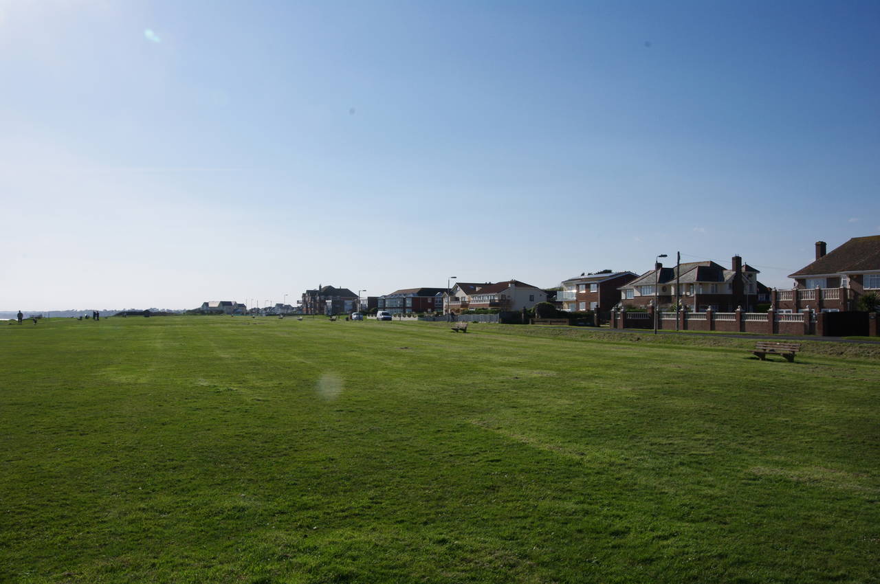
After about 700 metres, a group of buildings perched close to the cliff edge forces the path to bear right to join Marine Drive. Beyond the buildings and a carpark, the path returns to the clifftop, where once again a wide grassy strip of land provides a buffer for the town (picture 10).
A kilometre after rejoining the clifftop, the path reaches the fence of the huge Hoburne Naish Holiday Park, forcing another, much longer, foray inland. The path follows a footpath beside the fence through a residential area, crossing the ends of Marine Drive West, Purbeck Road and Vectis Road before turning right and passing more houses. Reaching Ellingham Road, the path crosses over and continues along another footpath that winds its way between houses, eventually reaching Glen Close, which the route crosses over, bearing left to join another footpath that leads to the busy A337 Christchurch Road.
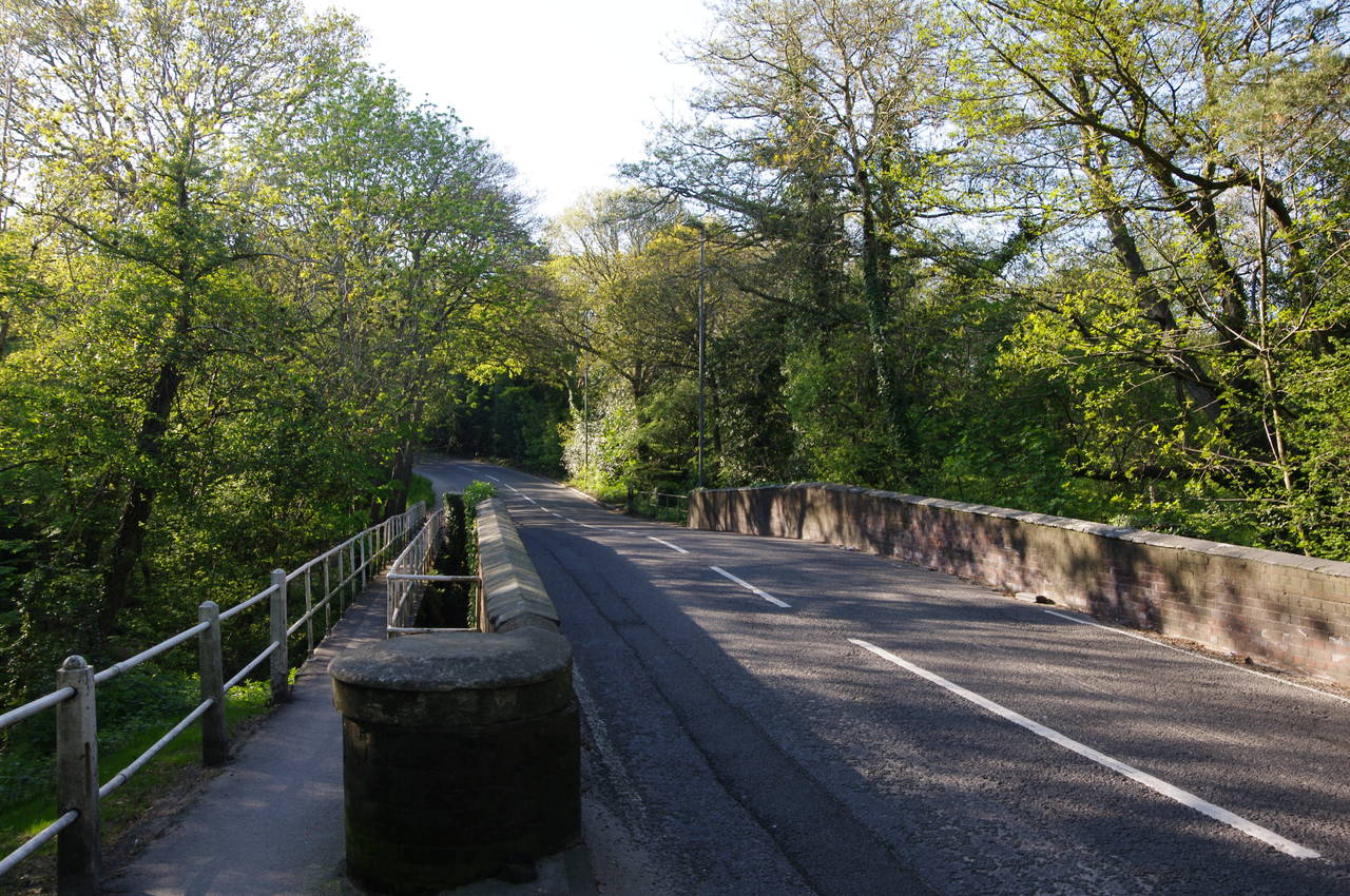
The route follows the road to the left, passing by the entrance of the holiday park before reaching a bridge over Walkford Brook (picture 11). The brook runs down into Chewton Bunny and also marks the county boundary between Hampshire and Dorset. The bridge itself is England's oldest steel-reinforced concrete bridge, built in 1901.
The Bournemouth Coast Path crosses the bridge into Dorset and then turns left off the road to follow an unsealed footpath through woods above the brook, gradually descending into Chewton Bunny, until about 200 metres short of the beach, the path emerges from the woods (picture 12).

(13) View from Highcliffe

(14) Zigzag path up to Highcliffe Castle

(15) Highcliffe Castle

(16) Steamer Point Woods
Just short of the beach, the Coast Path bears right, climbing up steps out of Chewton Bunny to a clifftop carpark at the town of Highcliffe. From the top of the cliffs I got my best view yet across Christchurch Bay (picture 13) to Hengistbury Head and Mudeford Quay, with the narrow opening of Christchurch Harbour just visible between them.
Just beyond the end of the carpark, the main path bears left to descend to the shingle beach, which is followed for a short distance to a steep zigzag footpath (picture 14) that returns to the clifftop in woods near Highcliffe Castle. The zigzag was built in 2005 and is the first of a dozen or so zigzags providing access to beaches along the coast between Highcliffe and Poole.
The path passes close to Highcliffe Castle (picture 15), built in 1835 by Lord Stuart de Rothesay, as a mansion rather than a military installation. Continuing through the clifftop woods, and ignoring steps down the cliff, the Coast Path heads through Rothesay Park and into the Steamer Point Nature Reserve, where I rested for a few minutes on an unusual park bench (picture 16).

(17) Beach huts at Friar's Cliff
(18) Avon Beach

(19) View from Mudeford Quay
(20) Mudeford Quay
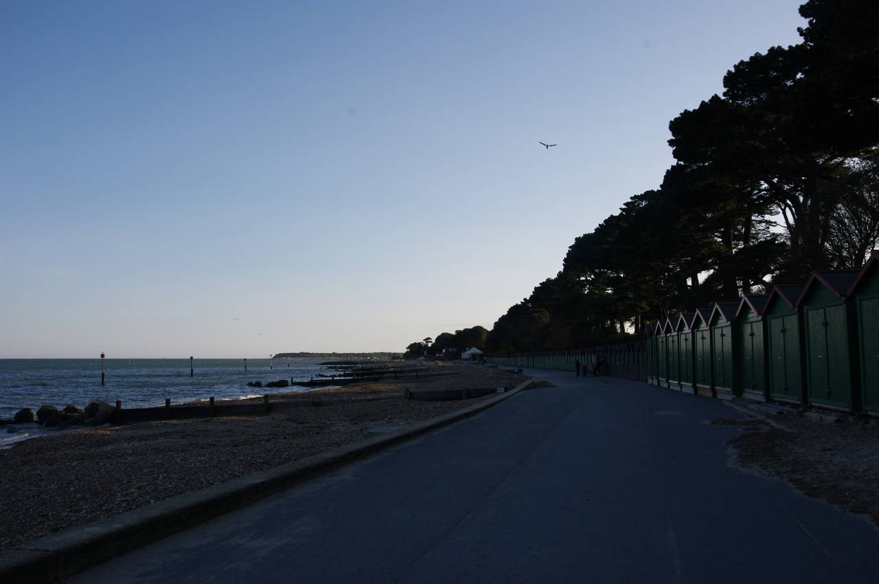
A few minutes walk further west, the path leaves the woods and passes a Maritime and Coastguard Agency training centre before descending through a wooden gate to the beach below Friar's Cliff (picture 17). The path heads between two rows of colourful beach huts to a café, then follows the beachside promenade in front of the beach huts.
At the end of the row of huts, the official route heads up a narrow footpath along the top of the low cliffs behind another longer row of more uniformly coloured huts. I missed this path and instead continued ahead in front of the huts (picture 18). Beyond the huts, a café and a carpark, I rejoined the official route, which descends back to the beach.
The final stretch of the day's walk follows a tarmac promenade above the last part of Avon Beach and then along the top of the sea wall with a caravan park then a car park on the right to reach Mudeford Quay, and the end of this stage of the walk, at the entrance of Christchurch Harbour.
Across the narrow channel of the harbour entrance is the tip of the Mudeford Sandbank, with the Isle of Wight lined up nicely in the background, about 13 kilometres away (picture 19).
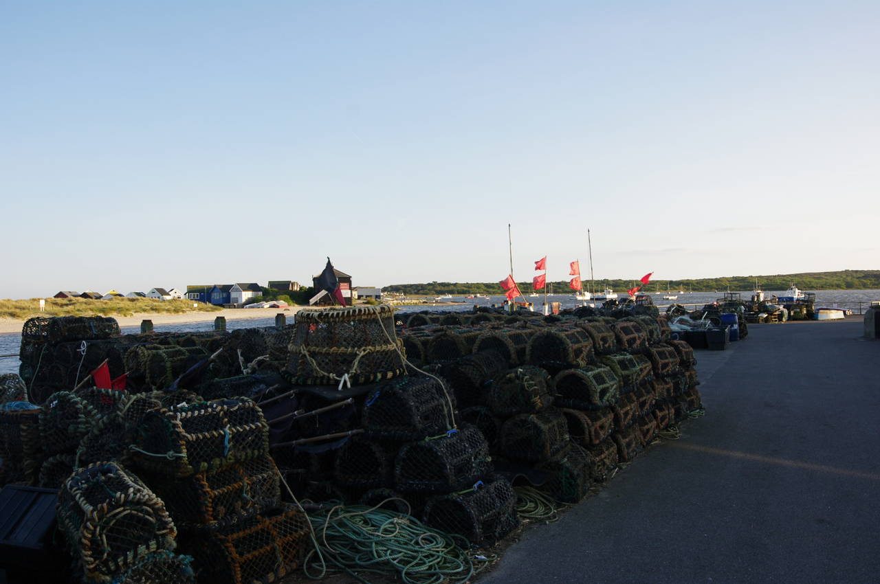
Still a busy centre of fishing activity, the quayside was piled high with nets and lobster baskets (picture 20), the fisherman having packed up for the day well before my arrival a few minutes before seven o'clock in the evening.
Reaching the point near the end of the quay where a small ferry carries passengers across to the Mudeford Sandbank, my GPS showed 15.3 kilometres walked from the beginning of the path by Sturt Pond.
From Mudeford Quay, I had almost an hour's walk on mainly residential streets to get to the nearest railway station at Christchurch. This was one of my longer walking days -- having walked the final stage of the Solent Way in the morning and with the addition of walks to and from railway stations, I had walked just over 40 kilometres for the day by the time I was ordering a well-deserved pint at the bar in my hotel.