SOUTH WEST COAST PATH NATIONAL TRAIL
Stage 24: Fowey to Charlestown
Sunday, May 25, 2014
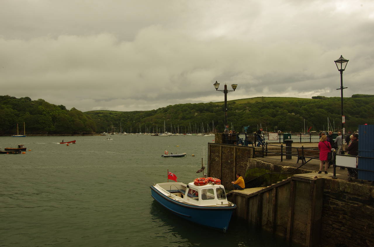
(1) Town Quay, Fowey

(2) St Finbarrus Church, Fowey

(3) Polruan

(4) Readymoney Cove
My most vivid memory of this stage of the walk is of freezing cold wind, and with most of the day's walk being on exposed clifftops, it was a day where I felt the need to keep moving at a good pace just to keep warm.
After a steep walk down through Fowey from the bus stop at the top of town to the waterside at Town Quay (picture 1), I set off up the short Market Street to St Finbarrus Church (picture 2). From the church, I climbed Lostwithiel Street as far as a left turn into The Esplanade, which runs parallel to the harbour behind waterfront houses. After passing the lane that comes up from the Whitehouse Quay where the ferry from Polruan usually arrives during the day, the Esplanade has views over gardens and across the harbour to Polruan (picture 3). The Esplanade continues above low rocky cliffs, soon becoming Tower Park and then Readymoney Road before curving around behind the sheltered sandy beach of Readymoney Cove (picture 4).

(5) Covington Wood
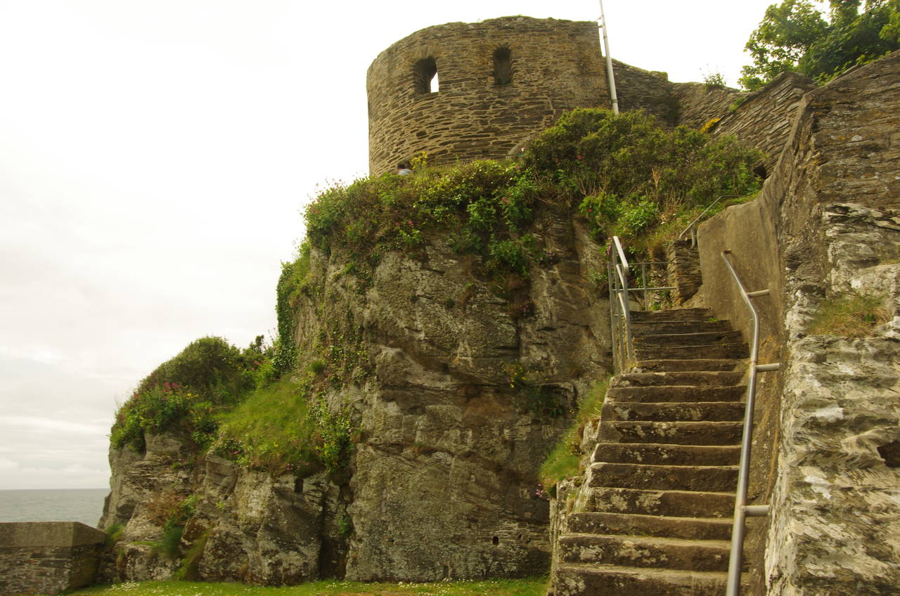
(6) St Catherine's Castle

(7) Fowey Estuary

(8) Coombe Haven
Behind the cove the Coast Path climbs up beside St Catherine's Cottage and into Covington Wood, where the sun came out briefly, for the only time in the entire day (picture 5). The path through the wood heads onto St Catherine's Point at the mouth of the Fowey Estuary. When the path emerges from the woods, a short signposted diversion downhill from the Coast Path offers a chance to visit the ruins of St Catherine's Castle (picture 6), where the remains of several generations of the harbour's defences can be inspected. This is also a good place to take in the views of the estuary (picture 7) before climbing back up to rejoin the Coast Path, which now hugs the clifftops for about 500 metres before descending into the little cove of Coombe Haven (picture 8).

(9) View from Lankelly Cliff to Gribbin Head

(10) Polridmouth
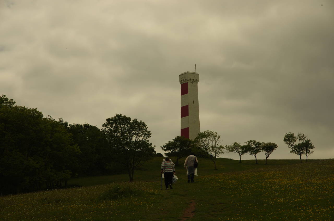
(11) Daymark on Gribbin Head

(12) Gribbin Head
Climbing out of Coombe Haven, the Coast Path resumes its journey around the low clifftops, first Southground Cliff and then Lankelly Cliff, from which there are views up to the distinctive daymark tower on Gribbin Head (picture 9). Before beginning the long climb up to Gribbin Head, one must find one's way around the deep inlet of Polridmouth, where two coombes come down to meet the sea at stony beaches on either side of a crumbling little headland. In the first coombe, the stream has been dammed to create a pretty little lake (picture 10).
After crossing a long boardwalk behind the second beach, the Coast Path makes a long, steady climb up Gribbin Head towards the daymark (picture 11), hugging the clifftops for the first half of the climb before taking a direct path after passing through a gate into the part of the headland owned by the National Trust.
The 26 metre high tower was built in 1832 to distinguish The Gribbin from other headlands on Cornwall's south coast and is occasionally opened for members of the public to climb the internal steps to the top. The three seaward sides of the tower are painted in red and white stripes.
From the foot of the tower, the Coast Path goes due west across an open meadow (picture 12) to a gate near the cliff edge, but there are no waymarkers near the tower so I went a little off course before finding the gate.
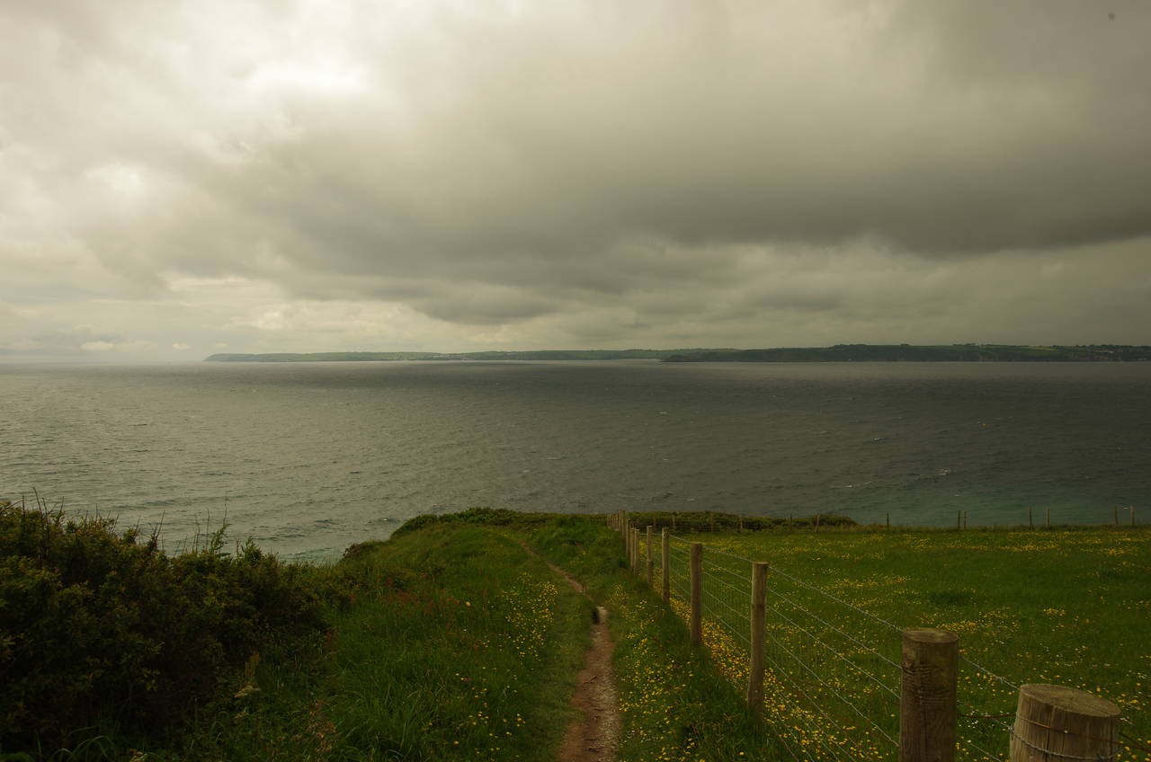
(13) St Austell Bay

(14) St Austell Bay

(15) Polkerris

(16) Little Hell
The path once again sticks close to the clifftops, skirting around a small bay to a corner at Little Gribbin, where there are far-reaching views across St Austell Bay (pictures 13 and 14). Here the path turns northwards for a fairly level two kilometre run along a rough path sandwiched between fenced fields and the cliff edge.
Eventually the path reaches a fork where a signpost indicates that the Coast Path heads downhill into a wood, zigzagging down to the small fishing village of Polkerris, situated at the foot of a coombe, like so many other settlements along this coast. The route goes down a slipway to the beach then immediately turns up beside the Rashleigh Inn then left across the small carpark to find the first of several flights of steps taking the route back up the side of the coombe. This is where the path has its best view of the village (picture 15) before climbing up through trees to regain the clifftop. The next stretch of the path runs through an area bearing the name Little Hell (picture 16), though it seemed reasonably pleasant to me aside from the chilly wind that was encouraging me not to linger.

(17) Par Sands

(18) View from Spit Point

(19) Carlyon Bay Hotel
(20) Charlestown Harbour
From Little Hell, the path runs northwards for a long and gradual descent past the eastern end of Par Sands (picture 17) and a few hundred metres further inland before the route turns left to cross a footbridge over a stream and reaches a large carpark. Heading southwards along the edge of the carpark, the path soon goes onto the wide strip of sand, turning westwards to run along the back of the beach for around a kilometre with the large industrial complex of Par Docks looming up ahead beyond a creek bordering the far end of the beach.
Par Docks are used for drying and exporting china clay, an important ingredient for paper production as well as for porcelain. The clay, which is blasted from granite by high-pressure water, is piped down to Par Docks from the hills above St Austell. The china clay industry has been one of Cornwall's biggest since the late 1800's when it took over from Cornwall's declining mining industry. Britain's entire supply of china clay is located in Cornwall and Devon.
Just before reaching the creek, the last of many paths heading up into the gorse-covered dunes behind the beach takes the Coast Path through the beach's much smaller western carpark and up to a left turn into a nature reserve. This is the beginning of a rather uninteresting two-kilometre inland diversion to get around the docks. A well-signposted path winds its way inland through the nature reserve for about 500 metres, crossing a road halfway before continuing beside a creek to reach the edge of the town of Par, where the path emerges between houses to turn left onto the A3082 Par Green.
The road is followed westwards, under the Plymouth to Penzance railway line and across the dock's private railway line before turning left on Harbour Road and passing back under the mainline again. The road is then followed alongside the dock complex until just before the road goes under the railway line for a third time, where the route of the Coast Path takes an enclosed footpath to the left of the railway line. The footpath, fenced on both sides runs between the railway and various industrial buildings for about 500 metres then turns left to cross a footbridge over part of the complex before running along the end of a golf course to return to the coast at Spit Point (picture 18).
The Coast Path now follows the crumbling cliffs beside the golf course for two kilometres to pass above a construction site at Carlyon Bay Beach before dropping down to cross Beach Road and run along the edge of a carpark to find the clifftop path past the front of the large Carlyon Bay Hotel (picture 19). Beyond the hotel the path continues to the seaward side of houses for almost a kilometre, but the narrow path is mostly enclosed by bushes until reaching Sea Road, where I had to stop to don my waterproofs as heavy rain arrived.
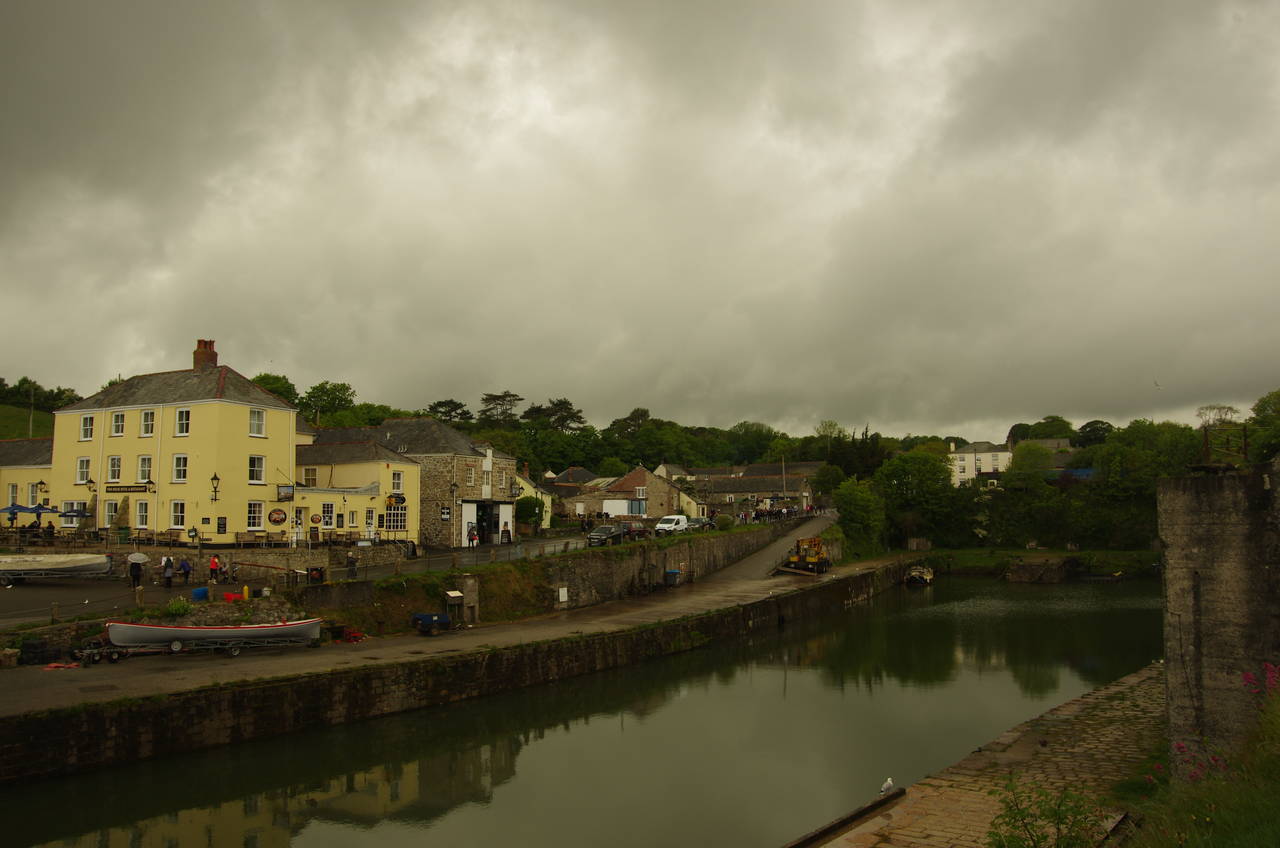
After 100 metres the route leaves Sea Road again, skirting around the backyards of four or five houses then turning left on an enclosed path that makes a long descent between fields to the harbourside at Charlestown (picture 20). I had read that Charlestown's harbour is home to three tall ships, though none of these were present when I arrived and the harbour was virtually empty.
The Coast Path goes all the way around the old harbour, but I left the path for the day at the back of the harbour, just outside the Shipwreck and Heritage Centre, with my GPS reporting that I had walked 17.3 kilometres from Fowey. From here it was another 25 minutes walk up Charlestown Road and on into the centre of St Austell, where I caught a train at St Austell Station.
This certainly hadn't been one of the most scenic stages of the Coast Path, but I was pleased to have completed it despite the cold weather and the rather wet end to the day.