COLERIDGE WAY
Stage 6: Brendon to Valley of Rocks
Tuesday, October 9, 2018

(1) Brendon

(2) Path to Countisbury Mill

(3) Countisbury Mill

(4) East Lyn River in Mill Wood
I awoke to bright sunlight streaming through the window of my room at the Staghunters Inn, pleased to discover that the final day of my walk in the footsteps of the romantic poets was going to be gloriously warm and sunny. With no phone signal in the village and no WiFi at the inn, I hadn't been able to check the weather forecast the previous evening, though the lack of modern communications technology in the sheltered Brendon Valley had ensured the best night's sleep I had had in ages.
After a late breakfast and a stroll up and down the quiet valley road to the opposite ends of the village, I crossed the long stone bridge over the East Lyn River to rejoin the Coleridge Way (picture 1). Turning downstream, the Way follows the road past another of Exmoor's iconic packhorse bridges before a shady footpath (picture 2) peels off on the left to pass by a small riverside pumping station and join the driveway of Countisbury Mill. The driveway heads for the mill buildings with the steep-sided valley narrowing ahead (picture 3). The Way is signposted between the main mill buildings and onto a riverside path through Mill Wood (picture 4).

(5) Mill Wood

(6) Wilsham Wood

(7) Bridge to Rockford

(8) Rockford Inn
The path soon passes a sign announcing the beginning of the National Trust's Watersmeet estate, which stretches all the way down the valley to the edge of Lynmouth. Beyond a gate, the Way is forced to climb around a fenced riverside area reserved for anglers who fish for Atlantic salmon that swim up the river to spawn in November and December. The higher path runs through an area of taller trees (picture 5) before dipping down again into Wilsham Wood (picture 6), which lines a long right-hand bend in the river.
Shortly after the river straightens, the path passes by a footbridge, which I used to make a diversion off the Coleridge Way, crossing over to the hamlet of Rockford (picture 7) and turning right to follow Church Hill past the 17th century Rockford Inn (picture 8).

(9) Church Hill

(10) Church of St Brendan

(11) Rockford

(12) View downstream from Ash Bridge
Following the road for about 700 metres, I climbed through the riverside woods (picture 9) and up to the Church of St Brendan (picture 10), which stands alone among farmer's fields. While this is the parish church for the village of Brendon, it is curious that the spelling of the village and its saint are different, and that they are three kilometres apart.
Returning to Rockford, I stopped off at the inn for a light lunch and a pint of ale brewed in the inn's own microbrewery before crossing back over the footbridge to rejoin the riverside path. A short distance downstream, just past Rockford Lodge, is the ancient fording point across the shallow, boulder-strewn riverbed from which the settlement takes its name (picture 11).
For the next kilometre the riverside path continues northward through Longpool Wood, with several small waterfalls tumbling down the opposite side of the valley and several spots where the river rushes noisily over jumbles of boulders. The next footbridge, where Longpool Wood gives way to Scrip Wood, is Ash Bridge. While the bridge is not crossed by the Coleridge Way, it does offer a nice spot to admire the views up and down the river (picture 12).

(13) Trilly Wood

(14) Watersmeet House

(15) Footbridge in Horner's Neck Wood

(16) Myrtleberry Cleave
A couple of minutes walk downstream from Ash Bridge, the river turns left and the Way follows it as it snakes for a kilometres through Trilly Wood (picture 13) to reach Watersmeet House (picture 14), a former fishing lodge that stands next to the confluence of Hoar Oak Water and the East Lyn River. The house is now a National Trust tearoom and visitor centre.
Now following the river through Horner's Neck Wood, the path soon passes an attractive stone footbridge (picture 15) before the river flows around two left-hand bends to enter Myrtleberry Cleave, where the path runs along the steep hillside well above the river (picture 16).

(17) Arnold's Linhay

(18) Tors Road

(19) Manor Green

(20) View back from May Bridge
The next one and a half kilometres of the path runs through woods labelled on the OS map as Wester Wood, but marked on several of the Coleridge Way signposts as Arnold's Linhay. This stretch of the river is very rocky (picture 17) and it must be quite a feat for the salmon that swim more than five kilometres upstream every winter. Below Watersmeet, the path was also much busier with walkers, most of whom were doing circular walks from Lynmouth to Watersmeet.
Eventually, the path emerges from the woods at the end of Tor Road on the edge of Lynmouth (picture 18). From this point onward, the river is enclosed between high stone walls, built in an attempt to avoid a repeat of the disastrous flood that devastated the village on the 15th of August 1952, taking thirty-four lives and destroying more than one hundred buildings.
The Way follows the road alongside the river to the pleasant Manor Green (picture 19), opposite a bridge where the West Lyn River emerges to join the East Lyn. Just downstream, beside the Rock House pub, the Way crosses May Bridge, the lowest crossing of the river, where one can view the extent of the work done to enclose the river (picture 20).

(21) Lynmouth Harbour

(22) The Rising Sun Inn

(23) Signpost by The Esplanade

(24) The Walker
Across the bridge, the Way turns right along Riverside Road to pass between Lynmouth Harbour on the right (picture 21) and the Rising Sun Inn on the left (picture 22). Turning left near the Rhenish Tower to follow the stone seawall alongside The Esplanade, I reached a fingerpost showing the long-distance routes that meet here (picture 23). A few steps further, a little alcove contains The Walker (picture 24), a new artwork installed here in May 2017.

(25) Westerway

(26) View towards Countisbury Hill

(27) North Walk

(28) The Warren
The official end of the Coleridge Way is just across the road at the Exmoor National Park Centre, but there is an optional extension to what I see as more fitting end to the Coleridge Way. This extension adds just over two kilometres to the length of the route, and another two kilometres to return to civilisation afterwards.
Climbing the steps beside the National Park Centre leads to Westerway (picture 25), an ancient path that zigzags up the steep hillside to the edge of Lynmouth's twin village of Lynton. Prior to 1828, when a road was built between the villages, the Westerway was the main link between them and all manner of goods, both legal and illicitly smuggled, were carried up the path by packhorses.
On the way up, the path crosses a couple of footbridges over the Lynton & Lynmouth Cliff Railway, which was a later addition, opening on Easter Monday in 1890. Just a few days after the cliff railway opened, Lynmouth became one of the first villages in England to be lit by electricity, powered by an early hydro-electric generator on the West Lyn River.
The bridges have good views across the mouth of the East Lyn River and Lynmouth Bay to Countisbury Hill (picture 26), providing an excuse to pause on the strenuous climb. Another reason to linger is given by various works of amateur poetry stuck onto posts by some of the many tourists visiting Lynmouth.
At the top of Westerway, the extension joins North Walk (picture 27), following it through woods to emerge on a ledge cut into the steep seaward face of Hollerday Hill, some 120 metres above the sea. The tarmac path runs along the ledge, where several hardy-looking goats were grazing beside the path, until a path branches left to climb over the ridge and turn sharp left to descend into The Warren (picture 28), part of the Valley of Rocks.

(29) The Poets' Shelter

(30) The Valley of Rocks
(31) The Valley of Rocks
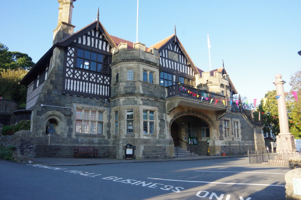
(32) Lynton Village Hall
At the bottom of the path, next to the valley road is the Poets' Shelter (picture 29), the end of the Coleridge Way extension. The route from Brendon to the Valley of Rocks had only been 9.5 kilometres (eleven with the excursion to the Church of St Brendan), but it had taken me six hours — rather slower than my normal walking speed — due to the many interesting views and photogenic spots along the route.
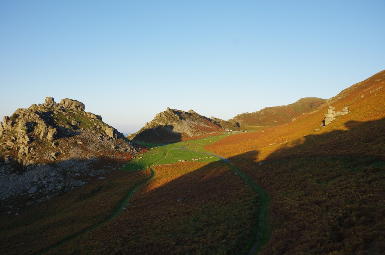
Taking a seat in the Poets' Shelter, I sat for a while to admire the late afternoon view westwards along the Valley of Rocks (picture 30). The valley, which runs parallel to the coastline, was formed by glacial activity in the last Ice Age, when Exmoor was at the southern extremity of the ice sheet.
In 1797, Coleridge and Wordsworth visited the valley and were inspired to compose The Wanderings of Cain together. Sadly, that collaboration was never completed and the 2000-word fragment that Coleridge wrote was not included in my little book of Coleridge's poems.
After wandering along the road to take in the reverse of the earlier view (picture 31), I backtracked past the Poets' Shelter and continued along the road into Lynton, passing the Lynton Village Hall (picture 32) before following North Walk and Westerway back down to the Rising Sun. As is my custom at the end of a long-distance walk, I parked myself at the pub and enjoyed a couple of celebratory pints to mark the completion of a very enjoyable journey along the Coleridge Way.