SOUTH WEST COAST PATH NATIONAL TRAIL
Stage 16: Dartmouth to Torcross
Saturday, May 25, 2013

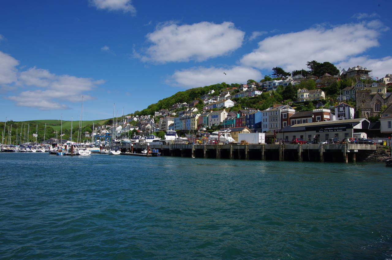
(1) View towards Dartmouth from Kingswear
(2) Kingswear

(3) Arriving at Dartmouth

(4) Approaching Bayard's Cove Fort
Another ride on the Paignton & Dartmouth Steam Railway on a perfect sunny Saturday morning was a great way to start the day. From the Kingswear side of the River Dart there were great views across to the town of Dartmouth, where rows of houses cling to the steep hillside of the drowned valley (picture 1). The short ride across the river on the pedestrian ferry provided similarly spectacular views of Kingswear (picture 2).
The ferry soon arrived at a jetty in front of what may be the only railway station in the world where a train has never called (picture 3). The small station building was constructed in 1864 with the expectation that the railway line down the far bank of the river would cross over to terminate on Dartmouth's waterfront. Those plans fell through and the station was left isolated from the railway, though it was still used by the many passengers getting the ferry across the river to join the railway at Kingswear until British Railways closed the line at the end of 1972. When the line reopened as a heritage railway the following year, Dartmouth Station did not reopen, but instead became a restaurant, which still operates today, with the building preserved and painted in Great Western Railway livery.
Dartmouth itself is an interesting town of around 6,000 people, with a history stretching back at least 1,000 years. The town was already well-established as a port by May 1147, when it was the embarkation point for more than 10,000 men sailing to the Second Crusade, followed 43 years later by a similar force bound for the Third Crusade. In June 1944, Dartmouth was also one of the departure points for allied soldiers taking part in the D-Day landings in Normandy, recalled by a memorial on the quayside.
A number of interesting medieval buildings and narrow medieval streets have survived on the hillside and a little further upstream the hill is topped by the imposing walls of the Britannia Royal Naval College, which has trained naval officers since 1905. The Coast Path sets off downstream, however, running along the cobbled quayside of the South Embankment (picture 4), which was built to reclaim a little flat land from the river.

(5) Bayard's Cove Fort

(6) View back from Warfleet Road

(7) Warfleet Creek

(8) Gun Tower and St Petrox Church
After a brief diversion onto a narrow street to get around the slipway of the lower car ferry from Kingswear, the path returns to the quayside as far as Bayard's Cove Fort, an artillery platform built in the early 16th century to defend the harbour from anything that might have made it past the twin castles at the river mouth. The route of the Coast Path goes through the fort, climbing steps to the road behind it, South Town, with good views over the fort towards Kingswear (picture 5).
The narrow road climbs gently southwards, eventually becoming Warfleet Road, along which there are several spots to admire the view inland along the Dart Valley (picture 6). A few hundred metres further, Warfleet Road curves right beside the inlet of Warfleet Creek (picture 7). At the head of the creek the route turns left into Castle Road, beside which an information board suggests that the place name has peaceful origins as a corruption of the Saxon name of the creek, rather than deriving from the creek's use as a sheltered marshalling place for the fleet that set off on the crusades.
The Coast Path follows the shady Castle Road as it curves around the other side of the creek and returns to the banks of the Dart to head up to the large Church of St Pertox and an adjoining Gun Tower belonging to the nearby Dartmouth Castle (picture 8). The Gun Tower was completed in 1495, though some other parts of the castle complex date back to 1388. During the 15th and 16th centuries a heavy chain was stretched across the river from the base of the tower to defend the Dart from invading ships. This solution was employed again during World War II to keep German ships and submarines out of the Dart.
A footpath around the landward side of the church leads to the main castle building, which stands on a small headland facing the neighbouring Kingswear Castle, about 400 metres away on the opposite bank of the Dart.

(9) Dartmouth Castle

(10) Sugary Cove

(11) View from Blackstone Point

(12) Compass Cove
Most of the original fort of 1388 no longer exists, except for one tower and part of the curtain wall. The remaining tower, St Lawrence's Tower, stands above a Victorian-era gun battery (picture 9), which is managed by English Heritage and is open to the public. Before continuing on the Coast Path, I spent an hour looking around the battery and the Gun Tower.
From the carpark behind the battery, the Coast Path climbs a tarmac path past the end of the remaining section of castle wall, overlooking the rocky Castle Cove, to find a steep flight of steps up to a rougher path. The path heads through trees above a picnic area at Sugary Green, which separates Castle Cove from the equally rocky Sugary Cove (picture 10).
The path zig-zags uphill behind the cove, briefly rejoining Castle Road before bearing left down a gravel driveway at a fork in front of a cottage. A short distance downhill, the driveway forks again and the Coast Path is signed along the right branch, through trees and scrub up to the tip of Blackstone Point, which marks the extremity of the Dart Estuary and has good views across to Outer Froward Point (picture 11).
Once around the point, a well-worn path runs towards Compass Cove (picture 12), detouring steeply some distance inland just before reaching the cove to circle around a boggy combe.

(13) Combe Point

(14) Start Bay
(15) Redlap Lane

(16) Combe beside Redlap Lane
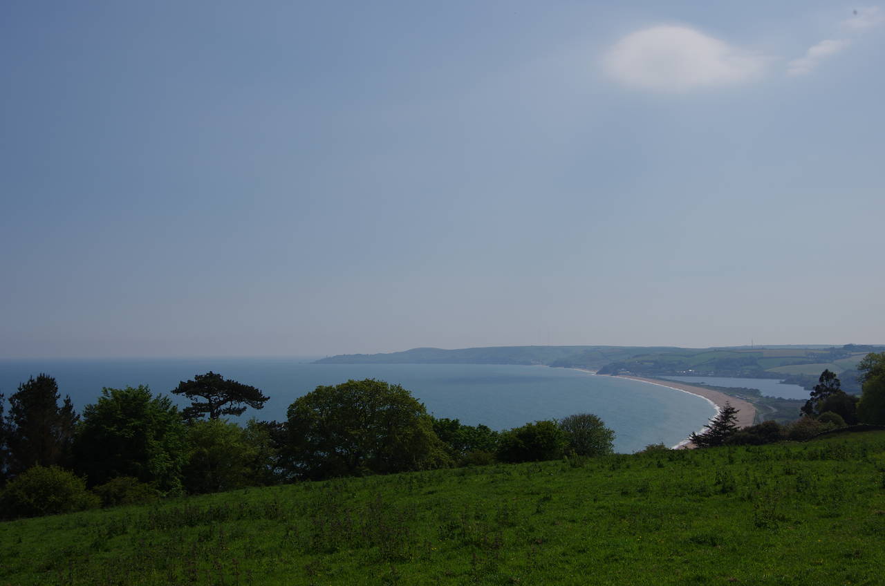
The path soon follows field edges back to the clifftop, then continues to follow them above Willow and Shinglehill Coves to reach Combe Point (picture 13). A right turn atop the point opens up views across Start Bay to Start Point (picture 14), but the views are short-lived. After following the seaward edges of two more fields, the route of the Coast Path turns away from the clifftops for a lengthy detour inland.
About 500 metres inland along a field-edge path, the route reaches a National Trust carpark at Little Dartmouth Farm, crossing it to turn left into Redlap Lane, heading for the village of Stoke Fleming, just over a kilometre away (picture 15). About halfway, the lane suddenly kinks to the right to get around a picturesque steep-sided combe (picture 16) before resuming it's previous course towards the village.

(17) Stoke Fleming

(18) A379 near Blackpool Sands

(19) Blackpool Sands

(20) Valley above Landcombe Cove
On reaching the main road in Stoke Fleming, the route crosses half-left to find a gate beside a stone bus shelter, leading into a sports field (picture 17). A tarmac path is followed around the left-hand edge of the field to the far side, crossing Venn Lane half-right to enter a driveway and almost immediately turning left onto an enclosed footpath through a patch of woods to emerge on Rectory Lane. The route follows the lane to the left, shortly crossing Church Lane to enter Old Road, which runs southwards beside the high stone wall of Stoke Fleming Church.
Leaving the village behind, Old Road runs downhill between tall hedges to eventually meet the A379 Blackpool Hill to the east of the popular beach at Blackpool Sands (picture 18). The Coast Path follows the left-hand side of the main road behind the beach, to which I made a quick detour to visit the handy café for refreshments. Just past the turn off to Blackpool Valley Road, where there is a row of attractive thatched cottages, the route crosses the main road and joins an enclosed path that runs parallel to the road for a short distance before crossing over Noms Lane, climbing through a small patch of woodland and then climbing across a field to the west of the beach. As the path climbs higher there are good views back over the beach (picture 19).
At the top of the field the path crosses a stile and joins a sunken track running southwest between fields. At a junction of tracks the route turns left, and after a few metres crosses a stile in the hedge on the right, entering a pasture and crossing it diagonally towards a signpost at the corner of a stone wall. The route then continues ahead to the far edge of the field, following it to the left to find a stile not far from the bottom of the field. A path through a short section of scrub leads into another field, where the lower edge is followed to a stile beside the A379. Another stile opposite takes the path on a steep scramble across the grassy valley above Landcombe Cove (picture 20), climbing up to join a fenced path above the clifftops.
(21) Approaching Strete

(22) King's Arms, Strete
(23) Start Bay

(24) Boundary Stone near Slapton Ley
This path soon leads into a long field, where the Coast Path climbs up the right-hand side, gaining views over the village of Strete after getting to the summit of a small hill (picture 21). Eventually the path reaches a gate in the corner of the field, turning right through trees to follow a field-edge path above a thickly wooded gully in the direction of the village. A sturdy footbridge over the gully takes the path up to a concrete driveway, which the Coast Path follows out to join the A379 once again, this time turning left to follow the road through the centre of the village, which is dominated by the large King's Arms pub (picture 22).
The fairly busy road is quite narrow in places and lined with stone walls for much of its length, lacking a pavement or verge. My progress along this section was quite slow as I had to stop regularly to keep out of the way of traffic, though in one place there was at least an opportunity to stop and take in the view over Start Bay and the freshwater lake of Slapton Ley (picture 23).
After following the road for a little over a kilometre, the Coast Path is signposted down a track on the left of the road. The shady track makes a long and gentle descent to a carpark at Strete Gate, behind the beach at Slapton Sands. About halfway down the track I passed what appeared to be an old railway carriage converted into a caravan.
(Update: In May 2019, I discovered that the walk along the A379 has been shortened, with a new footpath leaving the road about 200 metres beyond the King's Arms. This path parallels the road for a while then dips down through woods to rejoin the original route about halfway down the track to the Strete Gate carpark.)
Just beyond the carpark the A379 comes down to run alongside the beach. The Coast Path runs a short distance through the grass on the left side of the road before crossing over to run along the middle of a wide strip of scrub between the road and the ponds and marshes of Slapton Ley. Before long the path passes a marker stone denoting the boundary between the Strete Estate and the Whitley Wildlife Conservation Trust (picture 24).

(25) Monument at Slapton Bridge

(26) Slapton Ley

(27) Sherman Tank memorial at Torcross

(28) Torcross
The Ley is a freshwater lake, cut off from the sea by a four kilometre long shingle bank formed by material washed up by the rising seas at the end of the last Ice Age. Some distance along the bank, the path crosses back over to the seaward side of the road, and then back again after a few hundred metres, just before reaching a T-junction at Slapton Bridge, where a side road crosses the Ley towards the village of Slapton.
Across the main road stands a tall stone obelisk that commemorates the use of the area around Slapton by American forces training for the D-Day landings in 1943 and 1944 (picture 25). The Coast Path continues along the edge of the Ley however (picture 26), and after about two kilometres it reaches a carpark on the edge of the village of Torcross, which surrounds the southern end of the Ley.
At the far end of the carpark is another memorial recalling the American presence in the area leading up to D-Day. The memorial to Operation Tiger features a Sherman Tank that was aboard one of two American ships sunk by German torpedo boats off Torcross on April 28, 1944, less than six weeks before D-Day. The tank sat on the seabed for 40 years before being recovered in 1984 and placed here as a memorial to the 946 American servicemen who lost their lives in the tragedy.
From the carpark there is a signposted crossing of the road to the village's short seafront promenade (picture 28), at the end of which I left the Coast Path for the day, after 16.3 kilometres. On the promenade is the Start Bay Inn, where I brought a serving of fish and chips to eat on the beach before a fairly long bus ride back to my accommodation in Plymouth.