THE SAXON SHORE WAY
Stage 2: High Halstow to Rochester Castle
Thursday, December 30th 2010
I walked this section of the Saxon Shore Way on another foggy day, though slightly less so than the day before.
To rejoin the trail, I caught the 191 bus from Chatham Railway Station to High Halstow (one must be careful as it appears that not all 191 buses follow the same route). From the village it was little more than ten minutes walk along Britannia Road to the point where I had left the Saxon Shore Way the previous afternoon.

(1) Petrol station on Fenn Street

(2) Caravan next to the path

(3) Parbrook House

(4) New road construction
The route continues a short way to the end of Britannia Street, crossing the busy Fenn Street and following the road to the right for a short distance until a signpost indicates that the route heads around the side of a petrol station (picture 1) and along a somewhat overgrown hedge-lined path. A short way along the path a sign wrapped around a marker post states that there are rabbit holes in the footpath, and before long there are indeed many rabbit holes that must be carefully avoided. There was also an old abandoned caravan being slowly engulfed by the local plant life by the edge of the path (picture 2).
After passing through a couple of orchards, the path emerges onto a driveway in front of Parbrook House, where Christmas ornaments were still placed on the lawn (picture 3), but the route turns to the right, heading away from the house down the long, and mostly unsurfaced, Roper's Green Lane.
After slightly more than a kilometre, the Lane crosses a railway line and further on it crosses a road that was still under construction (picture 4).

(5) Lakes at Abbots Court

(6) The River Medway

(7) Hoo Marina

(8) Hoo Marina
The Saxon Shore Way continues ahead along a surfaced path to a T-junction near Tile Barn Farm, where the route turns left. The path soon becomes unsurfaced once again before reaching Stoke Road. The route briefly follows Stoke Road to the left before turning off to the right along another muddy footpath, which it follows straight ahead between two large lakes at Abbots Court (picture 5) and all the way to the floodbank beside the River Medway (picture 6). Standing on top of the floodbank I could hear the sounds of the Kingsnorth Power Station off a kilometre or so to the left, but the building itself was hidden in the fog.
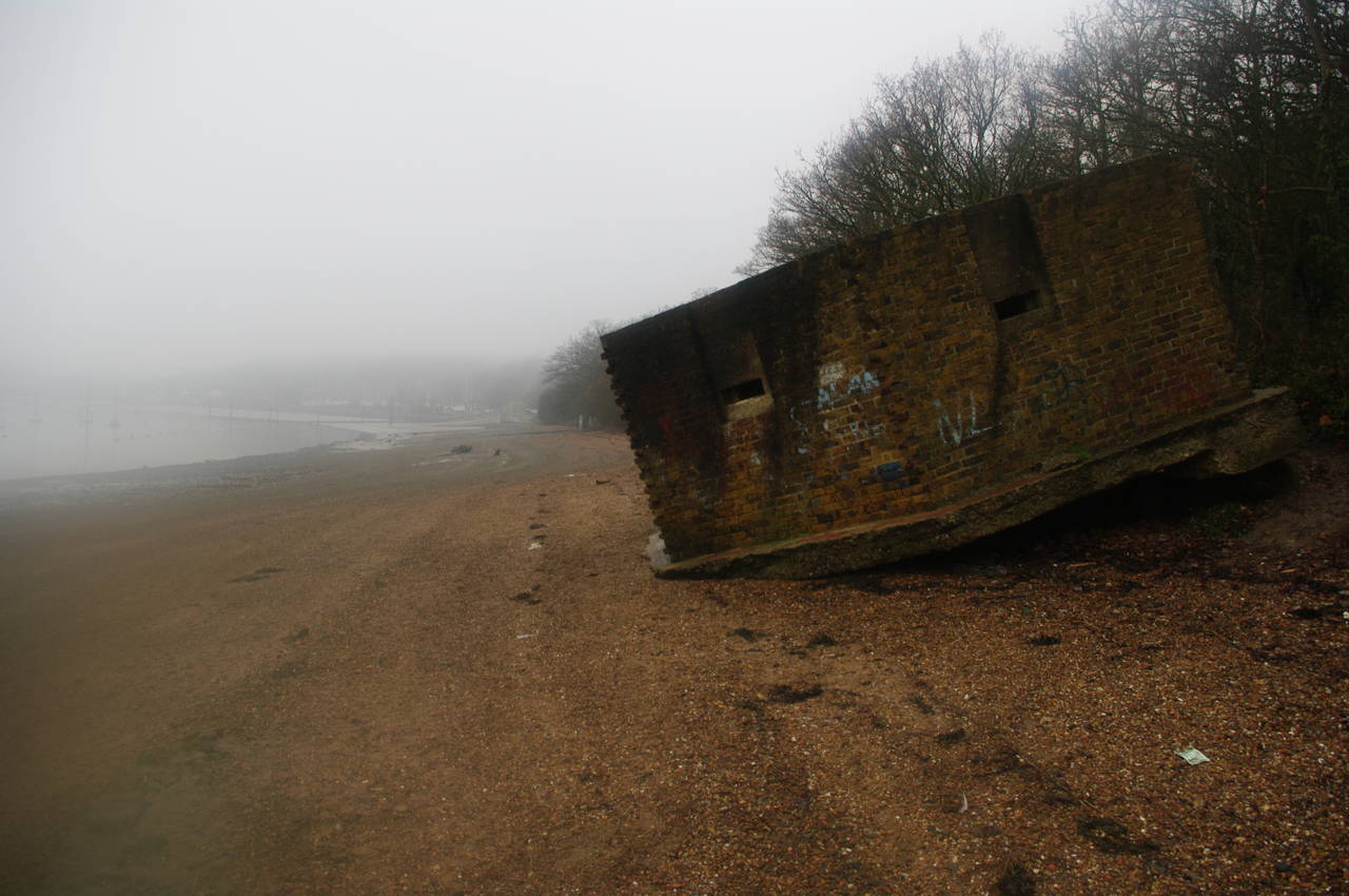
The Saxon Shore Way runs along the floodbank in the opposite direction however, passing a couple of WWII pillboxes before reaching the Hoo Marina Park (picture 7). The path descends from the floodbank through a metal kissing gate beside a brick building where I found a convenient step on which to sit down and eat my lunch.
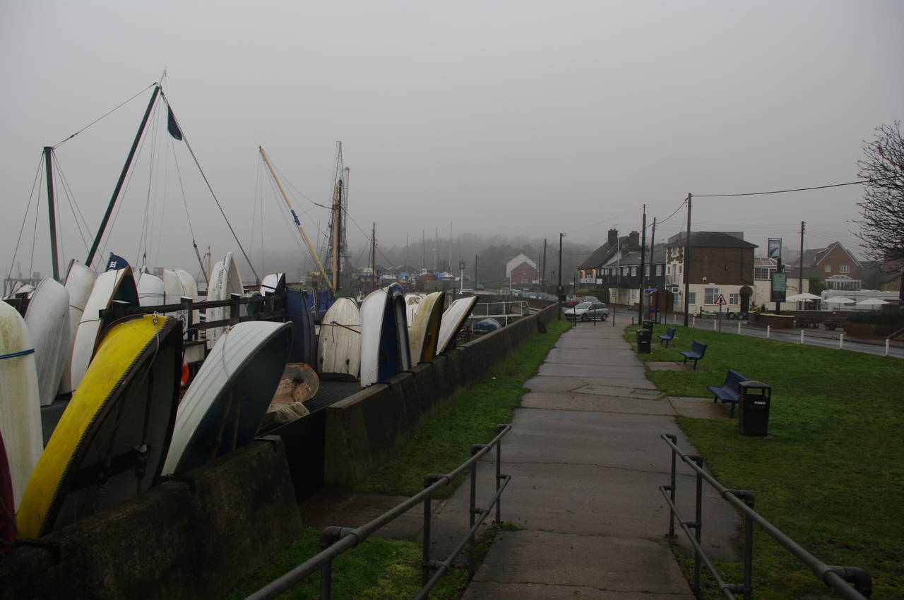
From here, the route follows various unphotogenic footpaths and lanes behind a series of marina buildings and boatyards (picture 8).

(9) Old boat in the Medway

(10) Crumbling brick building
(11) WWII Pillbox
(12) Lower Upnor
Eventually the route leaves the marina behind and runs along the shingle of the riverbank, where a number of old boats can be seen rotting away in the mud (picture 9). In the 18th and 19th centuries, this stretch of the Medway was home to dozens of stripped down old ships, known as "prison hulks", which were used to house large numbers of convicts. Whether the decaying boats in the river today are the remains of prison hulks or of something more modern I am unsure.
The path runs for about one and a half kilometres along the shingle, though the existance of an alternative inland route on the Ordnance Survey map, suggests that the riverside path might not always be passable. Part of the way along this section of path, a large brick structure is slowly disintegrating under the onslaught of the elements (picture 10), though it wasn't clear to me exactly what the original structure was supposed to be. Further along the riverbank, I passed another WWII pillbox, though this one didn't really seem to belong in its present location (picture 11).
Eventually the route leaves the shingle after crossing several slipways and follows a paved footpath along the riverfront at Lower Upnor, passing more boatyards (picture 12) and then joining a road that passes a pub called The Pier.

(13) Upnor High Street

(14) The Tudor Rose, Upper Upnor

(15) Rochester Bridge

(16) Gatehouse, Rochester Castle
The road soon curves uphill to the right, but the Saxon Shore Way leaves the road and follows a footpath around the walls of Upnor Castle House to the top of Upnor High Street. The route then heads down the High Street (picture 13), which is lined with some interesting old buildings, including the Tudor Rose pub (picture 14).
At the bottom of the High Street, the route turns right and follows a rough dirt track for a short distance along the river. Soon the path curves to the right following a narrow path around an MOD property, eventually reaching a pedestrian crossing over the busy A289 road. Once over the road, the route heads up some steps and climbs over some open ground before briefly joining Parsonage Lane and then heading back downhill towards the Medway on another narrow, wire-fence lined footpath.
At the end of this footpath, the route would normally cross Commissioners Road and continue straight ahead into Canal Road. On this particular day the path straight ahead was fenced off and the waymarker signs for both directions had been turned ninety degrees to create even more confusion. To get back on the correct route, I had to detour to the right along Comissioners Road and then to the left down to Strood Railway Station, where the pedestrian underpass leads back onto Canal Road.
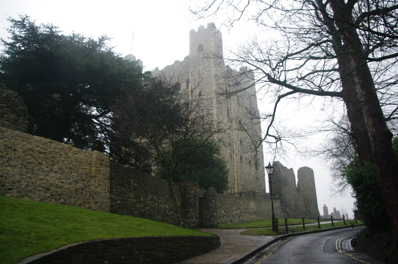
Continuing along Canal Road, the route goes under a railway bridge, crosses the road, then turns to the left along the pedestrian footpath of the Rochester Bridge, from which Rochester Castle and the spire of Rochester Cathedral could be seen off to the right (picture 15). Unfortunately the fog was too thick to see up river to the Medway Bridges, which I had crossed while walking the North Downs Way almost five months earlier. At the end of the bridge the route turns down to the right, passing the gatehouse of Rochester Castle (picture 16).
(17) View from Baker's Walk

(18) View from Boley Hill

(19) Rochester Cathedral

(20) Rochester Cathedral
The Saxon Shore Way then skirts around three sides of the castle via Baker's Walk (picture 17) and Boley Hill (picture 18). From Boley Hill the route then crosses the road in front of Rochester Cathedral (pictures 19 and 20), where I left the Saxon Shore Way for the day and headed through the town to Rochester Station. My GPS estimated that I had covered another 15.1km of the Way.